Solomon #2 received his first land grant 10 March 1752. At the time the grant was given, County lines were rapidly changing and the court clerk apparently wasn't sure which county the land was located in at that exact moment, so he wrote "Bladen or Anson County". The description on the land grant was for 640 acres along both sides of Cain Creek. Cane Creek runs along today's Orange, Alamance and Chatham County lines, but the vague description in the land grant doesn't allow us to pin-point exactly where this land was located.
Solomon #2 received his second land grant on the same date, 10 March 1752. This grant was for 640 acres, again in either Bladen or Anson County. But, this time an important landmark and clue was given. The grant was for acreage located at the mouth of Sandy Creek and included "improvements by Solomon Aldricks". Today, the exact spot where Sandy Creek branches away from Deep River is located at the western edge of the town of Ramseur in Randolph County. By this description we know where Solomon's land was located.
Also, by the words "improvements by Solomon", we know Solomon had been living on the land long enough to build a house, maybe some barns or other buildings, and possibly cleared farming land. This means he had been there for some time prior to March 1752, lending credence to the theory that the Allreds were in central NC possibly as early as the mid 1740's.
Solomon #2 is mentioned in a land grant received by Herman Husband per the book Orange County Records, Volume I, Granville Proprietary Land Office, Abstracts of Loose Papers edited by William D. Bennett. This book is on file in the Genealogy Room of the NC State Archives. On page 12, you'll find:
Husband, Herman Warrant 15 March 1755
640 acres on the head of a branch of Sandy Creek called Mount Pleasant on the east side of Deep River including a cabin built by Solomon Allred and claimed by Zach. Martin. Entered 15 Mar 1755 "In Lieu of an Entry made the 14 Nov 1754"
Surveyed 2 May 1755
This land was located "next door" to the land John Allred received a land grant for in 1755 when Thomas was living with him. So, by this we know that Solomon #2 was living "next door" to John and Thomas for a while.
A few years later, Solomon #2 apparently had moved a few miles south of John's land. In the book Orange County Records, Vol. V, Granville Proprietary Land Office, Deeds and Surveys, 1752-1760, edited by William D. Bennett, C. G., also on file in the Genealogy Room of the NC State Archives, Raleigh, NC, on page 131 you'll find:
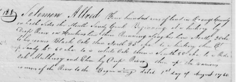
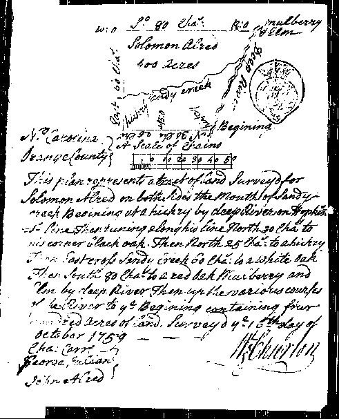
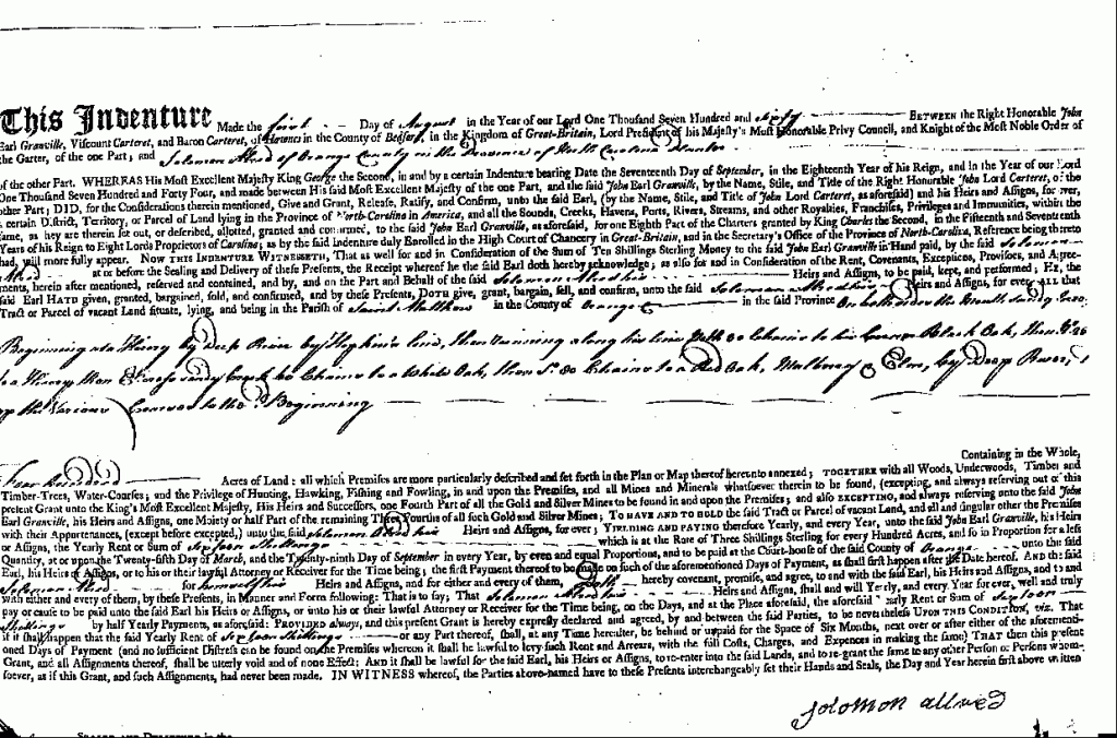 1 August 1760, Solomon Alred, planter, ten shillings, both sides of the mouth of Sandy Cr., begin at a hickory by Deep R. on Hopkin's line, along his line N 30 ch. to his cor. black oak, N 25 ch. to a hickory, E cross Sandy Cr. 60 Ch. to a white oak, S 80 ch. to a red oak, mulberry, and elm by Deep R., up river to beginning, 400 acres, sixteen shillings rent per year, surveyed 16 October 1759, George Julian and John Alred, CC. (SSLG 83-C) (Ed. note: see N. C. Patent Book 14:327).
Attached to this land grant was a plat map showing the land boundaries.In 1995, one of Solomon's descendants, Ralph Allred of Greensboro, drew a plat map per today's standards, giving us a much more detailed look at Solomon #2's original land.
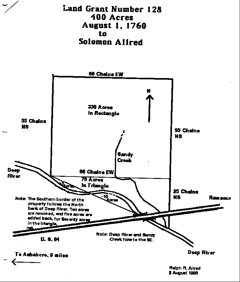
Using this information, we were able to pin-point exactly where Solomon #2's land was located. Using today's map, locate Asheboro (Randolph County) in the center of the state. Follow HWY 64 East from Asheboro to Ramseur. As you enter Ramseur you will cross the bridge over Deep River. If traffic allows, stop, get out and walk across this bridge looking at the water on the south side. You'll see the Sandy Creek as it leaves Deep River. The "mouth" of Sandy Creek is just south of the bridge, but is hidden by underbrush and trees. Get back into your car, drive 1/10 mile east, then turn north onto HWY 22. You are riding across Solomon #2's original land.
Another description of this same land is found in North Carolina Grant Book 14, page 327 (www.nclandgrants.com) Grant #128 Issued 1 Aug 1760.